
Chapter One
SOURCE: Pearson, M. (2005). Great southern land [PDF] : The maritime exploration of Terra Australis.
Link to PDF: https://search.follettsoftware.com/metasearch/rest/v2/go/113285/details/196747

Page 5

Page 6

Page 7

Page 8

Page 9

Page 10

Page 11

Page 12

Page 13

Page 14
The Spice Routes
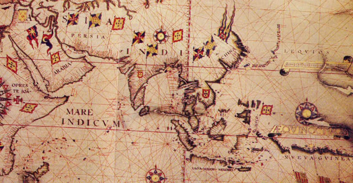
The Spice Routes were maritime paths linking the East to the West. Pepper, cloves, cinnamon, and nutmeg were all hugely sought-after commodities in Europe, but before the 15th century, North African and Arab middlemen controlled access to trade with the East, making such spices extremely costly and rare. With the dawning of the Age of Exploration (15th to 17th centuries), as new navigation technology made sailing long distances possible, Europeans took to the seas to forge direct trading relationships with Indonesia, China, and Japan. Some have argued it was the spice trade that fueled the development of faster boats, encouraged the discovery of new lands, and fostered new diplomatic relationships between East and West (it was partly with spices in mind that Christopher Columbus set out on his famous voyage in 1492).
The Dutch and English especially profited from the control of the spice trade in modern-day Indonesia, particularly the area known as the Moluccas, or Spice Islands, which was the only source of nutmeg and cloves at that time. Wars were fought, lands colonized, and fortunes made on the back of the spice trade, making this trade route one of the most significant in terms of globalization.
SOURCE: Cock-Starkey, Claire (2020) 8 Trade Routes That Shaped World History, URL: https://www.mentalfloss.com/article/86338/8-trade-routes-shaped-world-history
Useful Websites
 |
 |
 |
| What are Spice Routes? | How spices changed the world | The Dutch and the Spice Trade |
Brouwer's Route
Four hundred years ago a sailing voyage from Europe to Java, via Madagascar, would take almost 12 months, with an enormous toll on the health of all aboard. A shorter and safer route to the Indies was suggested by the Dutch theologian/ geographer Petrus Plancius in the late 1500s. He theorised that the voyage could be shortened by using the westerly winds to carry ships across the Indian Ocean in high latitudes, where the distance between longitudinal degrees was shorter.
Hendrick Brouwer sailed this theorised route in 1610 and found that he could reach the Sunda Straits in less than 6 months. The eastward flowing current in conjunction with constant winds in the same latitudes meant that high daily mileages were achieved. Further investigation by Pieter de Carpentier resulted in him advocating that ...
While the westerly winds were obvious to the navigators, they of course had no way of measuring the strength of the current sweeping them along. Their method of calculating longitude was therefore based on insufficient data. In 1616, Dirk Hartog in the Eendracht, using this route, made landfall on islands behind which could be seen a vast land mass which he named after his ship. He inscribed a pewter plate and left it nailed to a post on Dirk Hartog Island. In 1619 Frederik de Houtman on board the Dordrecht made landfall on the west coast much further south. Sailing northwards he came across low-lying islands with dangerous surrounding reefs, which he names Houtman Abrolhos because they were recognised as a potential hazard to ships using Brouwer’s route.
As the mainland and islands with their offshore reefs became better known to the VOC their sailing instructions were refined, and charts gradually became more accurate. Despite this, four Dutch ships and possibly more came to grief on the west coast, all four of them in the area covered by this work. It is also known that at least four ships’ boats from this period were lost and are waiting to be found. Those in command of VOC vessels were given strict instructions to follow Brouwer’s route but steer well clear of the known hazards. Commanders who failed to follow these orders faced a fine of 600 guilders. The Vergulde Draeck and Batavia were wrecked because of miscalculation of distance sailed east, while the Zeewijk was lost because of a deliberate flouting of the orders. Some other landfalls were made by vessels deliberately sent on voyages of exploration, such as the Geelvinck, Nyptangh and ’t Weseltje commanded by Vlamingh and the Witte Valke, Goede Hoop, Waeckende Boey, Emeloort and others specifically sent to search for the missing Vergulde Draeck.
Brouwer’s route was nevertheless used while the Dutch sent sailing ships to the Spice Islands, and considering the number of vessels which made the outbound voyage from Europe to the East Indies it proved to be a remarkably safe route. The invention of accurate chronometers (maritime clocks) in the 18th Century enabled longitude to be more precisely determined, making it even safer.
SOURCE: Worsley, P. & J. and Totty, D. (2008) A Windswept Coast: WA Maritime Heritage between the Moore River & the Zuytdorp Cliffs, Fremantle, WA Museum, pp333.

Useful Websites
 |
 |
 |
| Brouwer's Route | Hendrick Brouwer [Wikiwand] | Roaring 40s, Furious 50s . . . |
The Dutch East India Comapny
The Dutch East India Company (often called the VOC, the initials of its name in Dutch) was set up in 1602 to help Dutch traders and explorers work together to find and supply spices from across the world. Seeking riches in the South Land (as Australia was called), the VOC sponsored explorations increased the knowledge of the location, size and shape of Australia, as is evident in Dutch maps drawn and engraved during the 17th century. By 1628, about 4,000km of Australia’s western, southern and northern coastlines had been surveyed and delineated on charts which were issued to VOC skippers.
When the Dutch Ruled the World: The Rise and Fall of the Dutch East India Company
Useful Websites
 |
 |
 |
| The Rise of the VOC | Dutch East India Company | Mapping the Coast |
Additional Resources
SOURCE: History Animation Channel, posted on Youtube (2019) Duration: 5:23 Mins, URL: https://www.youtube.com/watch?v=7nItN2c6gZ4

The Age of Discovery, when European explorers uncovered whole new worlds, is well known, but what prompted this unprecedented push into the unknown? This animated video explores how spices provided the initial impetus for exploration and how one naughty dutchman opened the door for European colonial empires in Africa and Asia.
SOURCE: Real History on Youtube (2019) Duration 24:21 mins URL: https://youtu.be/3rb0HEtYaHw
Visualization of 18th and 19th-century shipping routes (based on ship's logs)
This shows mostly Spanish, Dutch, and English routes--they are surprisingly constant over the period (although some empires drop in and out of the record), from 1750 onwards. And there are some macro patterns -- the move of British trade towards India, the effect of the American Revolution and the Napoleonic Wars, and so on.
You get some individual voyages of interest. The Battle of Saldanha Bay (1796), when a contingent of Dutch ships sail south and engage with the British in August by the Cape, is clearly visible on the map; so is much of the Resolution's route on Captain Cook's second voyage (1772-1775) through the South Pacific, including its southernmost point. Some other events--the massive Spanish convoys in 1778 leaving from Peru, for example--I can't place as easily. The Beagle, unfortunately, is not represented.
SOURCE: Schmidt, Ben, Sapping Attention blog, posted on YouTube on 9 Apr 2012, Duration: 12:33 mins. URL: https://www.youtube.com/watch?time_continue=149&v=tnqxrcfUMsw&feature=emb_logo